Climbing the highest peak in the Lower 48, Mount Whitney, along with Mount Russell and Mount Muir
Andy Schlichting
0:00 / 0:00
Climbing the highest peak in the Lower 48, Mount Whitney, along with Mount Russell and Mount Muir
218 просмотров · 2 месяца назад
Andy Schlichting
337 подписчиков
218 просмотров · 2 месяца назад
I got an invite to head to the West Coast to climb three of California's 14ers in mid-June and jumped at the opportunity with our permit date on July 2. We were able to get an extra night in the Mount Whitney Zone through the lottery, allowing us time to climb all three 14ers in the Whitney Zone.
This was an ambitious goal coming from the Bay Area as these peaks are about a seven-hour drive from there. Our first night we camped at the Mount Langley trailhead to allow us to get an early start with just a 45-minute drive to the Whitney Portal.
From the Whitney Portal, we headed up the less-traveled Mountaineers Route trail to the base of Mount Russell (14,089 feet/4294m) at Upper Boy Scout Lake. After dropping some of our backpacking/overnight gear, we headed up past the lake to a class 3+ route to avoid the standard scree ascent. After scrambling up to the plateau, we headed to the ridge and navigated our way to the east summit on class 3 rock, and then over to the west summit, which is officially the high point of Russell, though from every aspect we viewed Russell from a distance, we thought the east summit looked higher. Regardless, the notorious knife edge seemed overrated to us.
Coming from Colorado, California 14ers have a reputation of being a grade higher than they would be rated in Colorado. However, I felt class 3 was fair for Russell. I would rate it 3+ and compare it to Capitol Peak in Colorado, which to be fair is considered class 4, but I personally would rate more like 3+. What I did find was the class 3+ terrain was more sustained on Mount Russell than it is on a typical Colorado class 3 route. A lot of Colorado peaks are rated by their most difficult move, even if it is literally only a couple of moves.
After descending quickly down the scree route from Russell, we collected our gear near the lake and then hiked up to Iceberg Lake at 12,600 feet to camp and prepare for the Mount Whitney summit the following morning. This made for a very big first day.
We woke early on July 2 and headed up the snow-filled couloir that is the Mountaineers Route on Mount Whitney (14,500 feet/4419m). The sun had really beaten this snow up already this year and created deep sun cups which made for an easy ascent with only microspikes--we did not use crampons. In fact, there were several sections of rock we had to scramble over that had already melted out in the couloir/chute.
After reaching the top of that section, the final 400 feet remained to the summit. We opted to stick to rock here because this section is steeper and the snow would've required crampons. The rock we climbed was to the climber's left of the snow and may have briefly touched class 4, but was mostly class 3. After some brief route finding near the top, we finished the climbing and had an easy walk to the summit and enjoyed the views from the highest point of the Lower 48 in the United States.
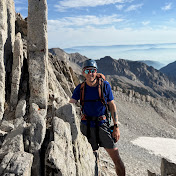
From Whitney's summit, we descended the normal route but stopped for a quick detour up to Mount Muir (14,028 feet/4275m). The initial ascent up Muir was a mess of steep, loose class 2 rock, but the final 50+ feet were a fun scramble up class 3-4 rock. From the basin below, Mount Muir is the more imposing peak with a sharp needle summit, despite Whitney being higher.
Finally it was time to head down the 97 (generally referred to as 99) switchbacks and beyond back down to the Whitney Portal. These were two very long, very physical days. We had a great team to push through it all.
Both the ascent and descent routes were stunningly beautiful with waterfalls, forests, lakes, marmots, and more. The Inyo National Forest and John Muir Wilderness are incredible and basically an extension of Yosemite, Sequoia, and Kings Canyon National Parks.
