Original Shanganagh junction to Shankill using overlay historical maps
Station to station
0:00 / 0:00
Original Shanganagh junction to Shankill using overlay historical maps
1 563 просмотра · 3 нед. назад
Station to station
851 подписчик
1 563 просмотра · 3 нед. назад
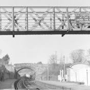
Using the National Library of Scotland maps ( OS 6 inch maps 1888-1915 ) starting at the junction 3 lines ran along the cliffs 2 lines to Harcourt st and single coastal line the modern map has the junction location has falling into the sea ! due erosion over the last 100 years Woodbrook golf club in that corner beside the cliffs is where the alignment was but the alignment can be walked up to the foot bridge aligned with trees now the tracks would have have curved towards the bridge at Quinn's road at the back of the gardens on Shanganagh grove is surviving embankment landscaped into the gardens the abutment and part of the embankment was removed in 1969 preventing the line from ever been built again the surviving abutment I wonder are curious why these bolder blocks are their with the embankment . it was cleared back over a year ago for a house been built beside the former embankment . the tracks were removed in late September 1960 and plate girder decking of the bridge removed in 1962. between the bridge and Dublin road bridge has been built with houses called The Grove bult on from the huge housing development at Dorney court and nearer the bridge you have houses beside the period house Cluain na Greine and apartments with landscaped gardens where the double tracks once were. contrast that with the other side of the bridge where the former track bed is overgrown with trees and undergrowth remains of the walkway buried in the overgrowth . before the former 1854 station the track bed has been built on contrast what is now with the o'dea photos from 1959 . A hideous extension was built on the station building in the 1970's the platforms and signal box and footbridge and wating shelter long gone Towards the Stonebridge road bridge is built on with industrial units and the former Ballychorus siding is now a car park . At the other side of the bridge has been infilled and in recent years a new footpath put in beside the cemented portal where soot marks are visible from bygone times.
