Climbing Little Bear Peak via the Southwest Ridge
Andy Schlichting
0:00 / 0:00
Climbing Little Bear Peak via the Southwest Ridge
82 просмотра · 2 недели назад
Andy Schlichting
337 подписчиков
82 просмотра · 2 недели назад
Some friends and I climbed Little Bear Peak (14,041 feet/4279m) in early September via the Southwest Ridge route. This is a rarely-climbed route which made route-finding challenging below treeline.
Little Bear Peak is located near Alamosa in the Blanca group in the Sangre de Cristo mountain range in southern Colorado.
We got an early start and the first few miles were easy on old 4x4 roads, but once we left the comfort of the roads, the route became steep and rugged. We had a solid 30 minutes of thick bushwhacking that led to a creek crossing across Tobin Creek. After this, the route got even steeper for a bit, though the bushwhacking was much better as trees and plants were a bit more spread out.
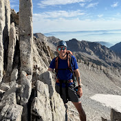
Finally we reached treeline and the route became obvious in the early-morning light and we followed the ridge over Mama Bear, to South Little Bear, and finally to the summit of Little Bear. As we got closer to the south summit, the terrain got more difficult and it reached class 4 with high exposure as we approached Little Bear's summit.
We descended the standard route through the Hourglass. This route that is notorious for deadly rockfall was easier than anticipated as there were no other groups around us to knock rocks down.
Eventually we got down the Hourglass and then the gully to the 4x4 Lake Como Road and took that about seven miles back down to our vehicles.
It was a big day with nearly 17 miles and 7,000 feet of elevation gain. We saw a rattlesnake just above 10,400 feet on the way up, and later ran into a small bighorn sheep on the ridge between the south summit and Little Bear.
